Geotechnical Gauge Manufacturer,Supplier and Exporter in India
Product Code : EL-SM-11915
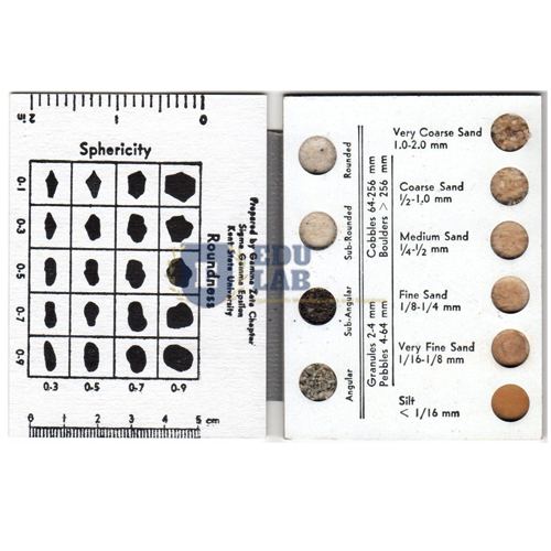
Quick Answer: The Geotechnical Gauge is a water-resistant 127 x 203 mm (5 x 8 in) plastic card on a lanyard, packed with information for classifying soils. It carries particle size classification under the Unified Soils Classification System, colour chips, sized grain patches, tables and edge scales.
Last updated: October 2026
Key Features
Water-resistant plastic card, 127 x 203 mm (5 x 8 in), on a lanyard.
Particle size classification by the Unified Soils Classification System.
Coarse and fine-grained soils in fifteen descriptive categories, from gravels and sands to silts and clays.
Sands graded from very loose to very dense; clays from very soft to hard.
Six colour chips, four patches of sized grains and four tables.
Worn on its lanyard, the card stays to hand while samples are described, letting the user match grain size against the sized patches, compare colour with the chips and check size against the edge scales. Separate guides grade sands by how loose or dense they are and clays by how soft or hard. Educational Lab Equipments can supply and export the Geotechnical Gauge to Bolivia, Honduras, Poland, Morocco and Cambodia.
Frequently Asked Questions
What does the Geotechnical Gauge classify?
Soils by particle size using the Unified Soils Classification System, coarse and fine-grained soils in fifteen categories, sands from very loose to very dense, and clays from very soft to hard.
How large is the card?
It measures 127 x 203 mm (5 x 8 in), with 0–6 in and 0–110 mm scales along its edges.